การจัดทำแผนผังภูมินิเวศแหล่งฟอสซิลเขาน้อยและป่าพน อุทยานธรณีโลกสตูล
Ecological landscape of fossil sources at Kao Noi and Pon Forest in Satun-Geopark


Source of Capital
National Research Agency (NRCT)
Main division
Faculty of Environment and Resource Studies
Joint Division
Palm Phatthana Subdistrict Administrative Organization
Main Operator
Project leader
Assoc. Prof. Dr.Nathsuda Pumijumnong
Project participants
Asst. Prof. Dr. Sukanya Sereenonchai
Assoc. Prof. Dr. Noppol Arunrat
Lect. Dr. Poonperm Vardhanabindu
Assoc. Prof. Dr.Nathsuda Pumijumnong
Project participants
Asst. Prof. Dr. Sukanya Sereenonchai
Assoc. Prof. Dr. Noppol Arunrat
Lect. Dr. Poonperm Vardhanabindu
Description
Satun Global Geopark achieved certification as Thailand's inaugural Global Geopark by UNESCO on April 17, 2018. The UNESCO Global Geoparks Council passed a resolution approving the Satun Global Geopark for re-evaluation in its pursuit of becoming a UNESCO World Geopark, ultimately receiving Green Card status in 2023. Notably, Khao Noi and Pa Phon harbor significant geological and fossil resources, yet there remains a deficiency in management and educational facilities for visitors. Consequently, this research aims to: 1) construct a landscape map of the Khao Noi and Pa Phon fossil sites in the Satun Geopark, and 2) formulate a learning path for these sites. The landscape planning process incorporates principles of conserving crucial geological resources and involves the division of areas based on geography, biology, social geography, and cultural geography. This is achieved through the use of maps depicting physical characteristics, drone surveys from aerial views, land use maps, rock layer maps, and the extent of designated fossil conservation sites. By overlaying and defining the area of use in each zone, the research prepares nature study routes and facilities by analyzing area conditions, potential and limitations, and user preferences. A travel route guide for the Satun World Geopark, specifically Khao Noi and Pa Phon, is then created by collecting relevant information on the Satun Geopark, ensuring academic accuracy, clarity, and interest. Opinions from participants are solicited, and young tour guides at Kamphaeng and Pa Phon schools undergo training. The study results in a landscape map of the Khao Noi area, comprising a reserved area of 6,511.85 square meters (4.070 rai), a conservation area of 72,834.55 square meters (45.522 rai), and a development area of 1,440.07 square meters (0.900 rai). Similarly, Pa Phon has a reserved area of 43,769.47 square meters (27.356 rai) and a development area of 29,532.45 square meters (18.458 rai). The reserved areas encompass rocks indicating different ages, fossil sites, and algae rocks. Conservation areas extend seamlessly from the reserved areas, while development areas are designated for nature study routes and minimal disruption to nature. Policy recommendations emphasize expediting the 5-year plan (2024-2028) for the Satun Global Geopark, aligning it with provincial and local development plans. The landscape map concept underscores the interconnectedness of geological sources, local communities, and the biosphere, advocating for sustainable use, balanced conservation, and high community participation. Nature study routes and facilities in Khao Noi utilize the Prehistoric scenery of the Ordovician period to foster interest. The concept of The Journey of Natural Nature: Local-Natural trail- Enhance focuses on community participation in activities, including local guides, food, crafts, plants, and nature. The Satun World Geopark travel route guide encompasses Satun Global Geopark, the Geological Time Table, Khao Noi, and Pa Pon.
Keywords: Satun Geopark, Khao Noi, Pa Phon, landscape map, Nature Trail, Fossils, Stromatolites.
Keywords: Satun Geopark, Khao Noi, Pa Phon, landscape map, Nature Trail, Fossils, Stromatolites.
Content
Project Objectives and Importance
UNESCO certified Satun Geopark as a World Geopark, or Satun UNESCO Global Geopark, on April 17, 2018, with evaluations scheduled every four years. The most recent assessment occurred from July 27 to June 1, 2023. The UNESCO Global Geoparks Council has approved the Satun Global Geopark for re-evaluation to maintain its UNESCO Global Geopark status, earning the Green Card designation. Furthermore, the Council has recommended preparations for the next assessment in 2026. Key issues identified include:
1. Providing clearer information on the connection between geological processes and cultural heritage, emphasizing traditional storytelling and local traditions through various communication channels such as information signs, brochures, websites, nature information signs, and guidebooks.
2. Enhancing geotourism promotion by highlighting interconnected geological stories throughout the UNESCO Global Geopark (UGGp) and encouraging visitors to explore beyond beach areas. This involves strategically placing information points, signage, museums, and infrastructure at popular tourist spots.
In response to these recommendations, this study proposes the creation of a landscape map for the Khao Noi and Pa Phon areas. This map serves as a tool for resource management and supports Satun Geopark's operations in the realms of communication, knowledge dissemination, and addressing geotourism concerns.
Details about the Research Objectives:
1. Develop a landscape plan for the Khao Noi fossil site and the Pa Phon forest within the Satun Geopark.
2. Create a learning path for the Khao Noi and Pa Phon fossil sites, aligning with UNESCO's recommendations and addressing the need for improved communication and geotourism promotion within the Satun Geopark.
Operation
The creation of a landscape plan for the Khao Noi and Pa Phon fossil sites in the Satun Geopark involved surveying and collecting pertinent cartographic data, including land use maps, geological maps, and aerial view surveys. The scope of application considered the National Park Department's guidelines regarding the use of the area for wildlife and plant conservation, specifically the declared conservation area for the protection of fossil sites. Additionally, an elevation map was utilized to delineate the landscape plan's boundaries, encompassing the Khao Noi and Pa Phon forest areas.
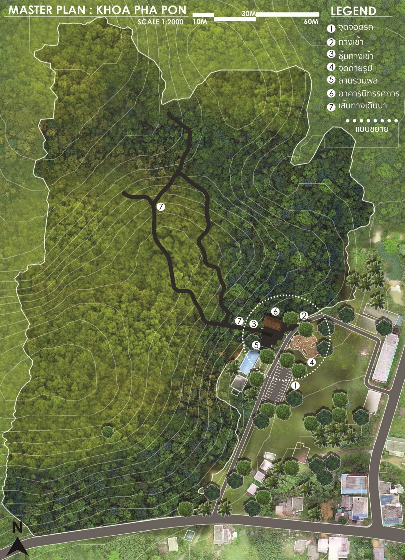
For the Khao Noi area, the Department of Mineral Resources' declared boundaries for fossil protection were adopted, covering an area of 51 rai and divided into three sub-areas. The reserved area, where two eras of rock formations meet (Ordovician and Silurian), includes Khao Hin Sarai. The protected area seamlessly extends from the reserved area, while the development area is designated for the nature study route and facilities such as exhibition buildings, parking spaces, and bathrooms along the roadside.
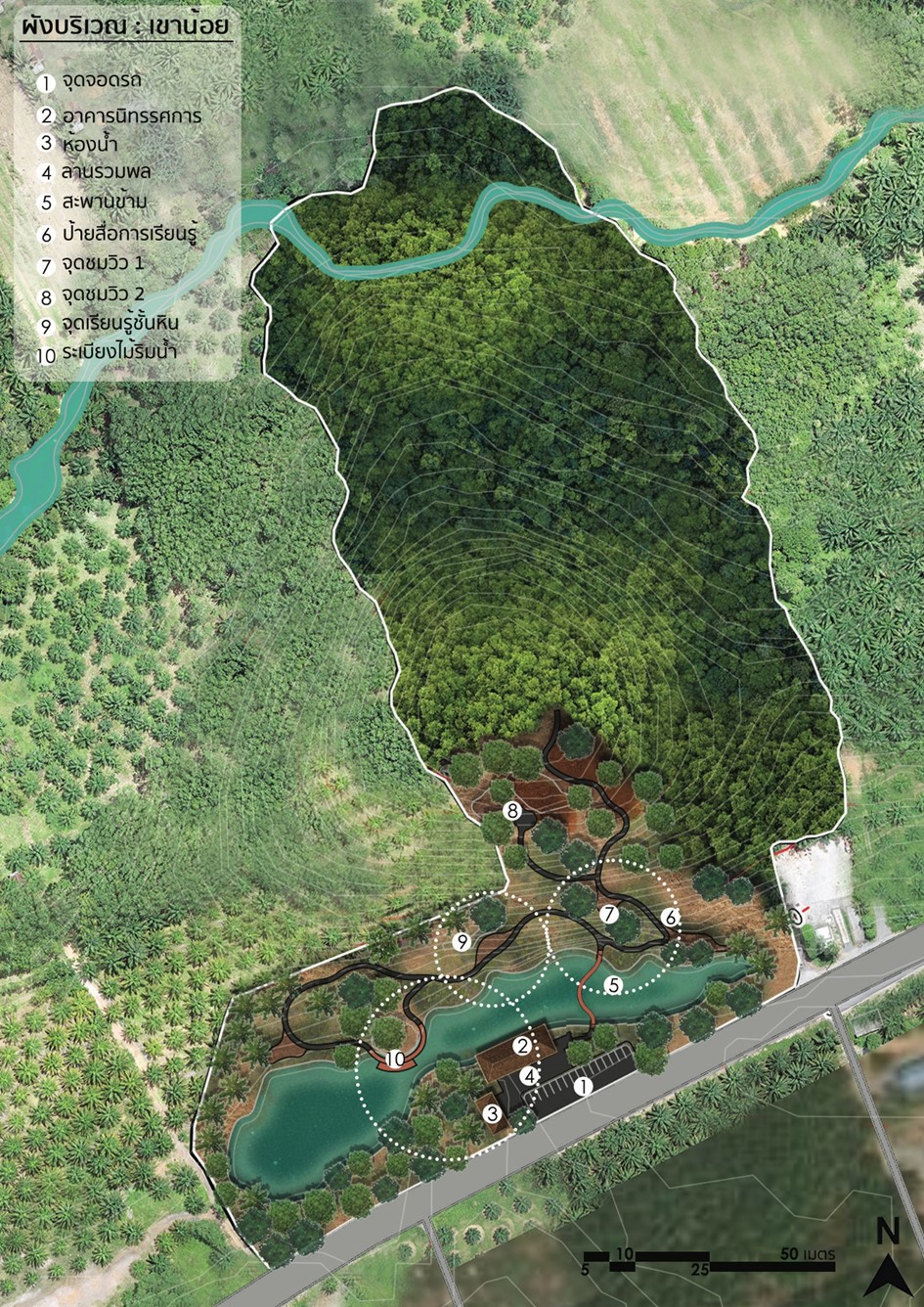
In the Pa Phon area, the boundaries of Ban Pa Pon School, approved by the National Park Department, were used. The area encompasses 28.8 rai and has been divided into three zones. The Khao Hin Sarai area to the west of the school, recognized as a significant geological resource, is designated as a reserve area. The remaining space constitutes a conservation area, including the seaweed rocks in front of the school building. The development area covers the school building and the nature study trail. A land use plan was devised to support Satun Geopark administration, involving environmental analysis through the PESTLE technique and strengths-weaknesses analysis. Stakeholder analysis was conducted, and a strategy for developing learning routes at the Khao Noi and Pa Phon fossil sites was formulated using the TOWS technique.
The operational framework focused on maintaining the natural state of the sites, ensuring the study line passes through the most interesting points. The subsequent steps included area analysis, with an analysis map detailing potential and limitations in resource development and user analysis. Design concepts for Khao Noi and Pa Phon were established: "The Prehistoric Scenery of Nature: Fossil Story, Sequence, Activities" for Khao Noi, and "The Journey of Natural Nature: Local, Natural Trail, Enhance" for the forest. A Satun Geopark tourism route guide for Khao Noi and Pa Phon was developed, collecting relevant documents and maintaining academic value, illustrations, and attractiveness. The final step involved a workshop for relevant agencies to critique the Khao Noi and Pa Phon landscape plan, area utilization plan, and Satun Geopark administration support. A prototype model of educational routes and facilities, along with a travel route guide for Satun Khao Noi-Pa Pon Global Geopark, was created. Subsequently, improvements were made, and training sessions were organized for young tour guides and teachers from Kamphaeng School and Pa Phon School to effectively use the Satun Geopark map, Khao Noi and Pa Phon Nature study trail model, and facilities according to the Satun World Geopark travel route guide. Operation Results The preparation of the landscape plan of Khao Noi and Pa Phon consists of 3 zones: the reservation area covering the area where Khao Sarai fossils were found; the conservation area is other areas that are connected to the reserved area; the development area is the area that will be a nature study route, where facilities will be built with the specific layout of Khao Noi that covers the reservation area of 6,511.85 square meters (4.070 rai), the conservation area of 72,834.55 square meters (45.522 rai), and the development area of 1,440.07 square meters (0.900 rai), and a specific forest plan.
The reservation area covers 6,339.25 square meters (3.962 rai), the conservation area 43,769.47 square meters (27.356 rai), and the development area 29,532.45 square meters (18.458 rai). Area use plan and support for the administration of the Satun Geopark should be taken including 1) upgrading the Geopark Learning Center, developing areas and management to meet standards 2) promoting geotourism services and developing the local community economy to the international level 3) infrastructure and facilities and 4) creating awareness of nature study routes and facilities. It was then designed and has gone through a feedback process from stakeholders. The design takes into account the preservation of fossil sources and the attractiveness of them, with minimal disturbance to nature. This includes the amenities, which would be modest and blend in with nature as much as possible. Therefore, the design idea was to use the Prehistoric scenery of the Ordovician period to create interest in the project by using the original landscape of the front area as a space that helps tell a story. Some landscape elements may be added to help promote a learning environment.
The Khao Noi fossil site will use the concept of The Prehistoric Scenery of Nature in its design, using the current landscape design to be similar in order to remember the past era when fossils were created by trying to preserve the original natural characteristics of the area as much as possible, and using the design of sequencing access to areas to help create interest and increase the impression of the area. For Pa Phon, an area where limestone and fossil sources are found, some parts are garden areas in the Ban Pa Phon School area. The garden-like area consists of limestone boulders, each layer clearly showing the structure of stromatolites. It is said to be Ordovician limestone, which is a good source of learning. The project area is divided into two main parts: the school area and the forest area behind which there is a nature trail. The original use of the area is quite clear. Together with the analysis of various aspects of the area, it was found that the design of usage characteristics should emphasize walking to study nature and learning about fossils in all 8 areas, emphasizing system adjustment and management of various systems, including service points and service routes in the area including parking spots, walkways, stairs, signs, shops, landscapes, and creating interest in various spots, including making suggestions for various activities that are appropriate to add to the area by emphasizing the local people’s participation in creating learning activities in the area as follows:
LOCAL GUIDE: students or people who are interested in the village can become tour guides to help with activities, maintain projects, and provide knowledge to tourists.
LOCAL FOOD: organizing community restaurants to serve tourists. They offer normal food and local food, which is a recommended menu of Satun Province.
LOCAL CRAFT: offering locals the opportunity to create handicrafts, or various inventions for display and sale to tourists There may also be handicrafts teaching for tourists
LOCAL PLANTS: encouraging the use of local plants, including knowledge about the benefits of various plants
LOCAL NATURE: importance given to the original natural characteristics of the area with a focus on encouraging tourists and visitors to see the beauty and impressiveness of the nature in the area, including trees, animals, and rock layers at all the 8 points. The nature trail guide for both Khao Noi and Pa Phon narrates stories about the origins of fossils in Satun, explaining the significance of the time period, seaweed rocks, and various fossil types found at Khao Noi.
Additionally, it presents information about the rainforest plants in the Phon forest, including an analysis of importance, the number of trees, and cross-sectional area for each perennial plant type in the Phon area. From the analysis, the top 5 species with the highest importance in the rainforest are Kra Bao (94.10%), Phaya Mu Lek (9.75%), Yang Mun Sai (9.25%), Sae (8.95%), and Mak Phon (8.73%). The survey also revealed the top 5 trees in terms of number: Phaya Mu Lek (14 trees), Sok Phu Khao (12 trees), pork fat (11 trees), Yang Man Sai, Mak Phon (10 trees), and Sae and Khai Khiao (8 trees). Moreover, the top 5 species with the greatest cross-sectional area are Kra Bao (1090.96 sq m.), Wild Kaffir lime (43.00 sq. m.), Priang Mai (15.42 sq. m.), Yang Mun Sai (10.00 sq m.), and Takhian Sai (9.82 sq m.). The evaluation of the Khao Noi and Pa Phon fossil sites is summarized in seven areas: geological uniqueness, geological diversity, rarity, evidence of geological history, completeness of fossils, biological diversity, and being a geological reference point.
Most respondents expressed the highest level of opinion about both sites (5 points). Regarding tourism supply chain management, the overall evaluation results before the trip were high (4 points), and during and after the trip, they were consistently at the highest level (5 points). This includes aspects of fossil sources, access/transportation/travel, conveying meaning, providing services, safety, and facilities. However, there are sub-issues concerning tourist activities during the trip. While most activities are well-organized to accommodate tourists/learners and received high evaluations, activities promoting participation received the highest and consistent scores. Therefore, there is an opportunity for further development in promoting tourism activities and encouraging participation.
Utilization: This project contributes to the research development in the Satun Global Geopark area, and stakeholders of the Satun Global Geopark can utilize the results of this research.
Published works related to this project -
UNESCO certified Satun Geopark as a World Geopark, or Satun UNESCO Global Geopark, on April 17, 2018, with evaluations scheduled every four years. The most recent assessment occurred from July 27 to June 1, 2023. The UNESCO Global Geoparks Council has approved the Satun Global Geopark for re-evaluation to maintain its UNESCO Global Geopark status, earning the Green Card designation. Furthermore, the Council has recommended preparations for the next assessment in 2026. Key issues identified include:
1. Providing clearer information on the connection between geological processes and cultural heritage, emphasizing traditional storytelling and local traditions through various communication channels such as information signs, brochures, websites, nature information signs, and guidebooks.
2. Enhancing geotourism promotion by highlighting interconnected geological stories throughout the UNESCO Global Geopark (UGGp) and encouraging visitors to explore beyond beach areas. This involves strategically placing information points, signage, museums, and infrastructure at popular tourist spots.
In response to these recommendations, this study proposes the creation of a landscape map for the Khao Noi and Pa Phon areas. This map serves as a tool for resource management and supports Satun Geopark's operations in the realms of communication, knowledge dissemination, and addressing geotourism concerns.
Details about the Research Objectives:
1. Develop a landscape plan for the Khao Noi fossil site and the Pa Phon forest within the Satun Geopark.
2. Create a learning path for the Khao Noi and Pa Phon fossil sites, aligning with UNESCO's recommendations and addressing the need for improved communication and geotourism promotion within the Satun Geopark.
Operation
The creation of a landscape plan for the Khao Noi and Pa Phon fossil sites in the Satun Geopark involved surveying and collecting pertinent cartographic data, including land use maps, geological maps, and aerial view surveys. The scope of application considered the National Park Department's guidelines regarding the use of the area for wildlife and plant conservation, specifically the declared conservation area for the protection of fossil sites. Additionally, an elevation map was utilized to delineate the landscape plan's boundaries, encompassing the Khao Noi and Pa Phon forest areas.
For the Khao Noi area, the Department of Mineral Resources' declared boundaries for fossil protection were adopted, covering an area of 51 rai and divided into three sub-areas. The reserved area, where two eras of rock formations meet (Ordovician and Silurian), includes Khao Hin Sarai. The protected area seamlessly extends from the reserved area, while the development area is designated for the nature study route and facilities such as exhibition buildings, parking spaces, and bathrooms along the roadside.
In the Pa Phon area, the boundaries of Ban Pa Pon School, approved by the National Park Department, were used. The area encompasses 28.8 rai and has been divided into three zones. The Khao Hin Sarai area to the west of the school, recognized as a significant geological resource, is designated as a reserve area. The remaining space constitutes a conservation area, including the seaweed rocks in front of the school building. The development area covers the school building and the nature study trail. A land use plan was devised to support Satun Geopark administration, involving environmental analysis through the PESTLE technique and strengths-weaknesses analysis. Stakeholder analysis was conducted, and a strategy for developing learning routes at the Khao Noi and Pa Phon fossil sites was formulated using the TOWS technique.
The operational framework focused on maintaining the natural state of the sites, ensuring the study line passes through the most interesting points. The subsequent steps included area analysis, with an analysis map detailing potential and limitations in resource development and user analysis. Design concepts for Khao Noi and Pa Phon were established: "The Prehistoric Scenery of Nature: Fossil Story, Sequence, Activities" for Khao Noi, and "The Journey of Natural Nature: Local, Natural Trail, Enhance" for the forest. A Satun Geopark tourism route guide for Khao Noi and Pa Phon was developed, collecting relevant documents and maintaining academic value, illustrations, and attractiveness. The final step involved a workshop for relevant agencies to critique the Khao Noi and Pa Phon landscape plan, area utilization plan, and Satun Geopark administration support. A prototype model of educational routes and facilities, along with a travel route guide for Satun Khao Noi-Pa Pon Global Geopark, was created. Subsequently, improvements were made, and training sessions were organized for young tour guides and teachers from Kamphaeng School and Pa Phon School to effectively use the Satun Geopark map, Khao Noi and Pa Phon Nature study trail model, and facilities according to the Satun World Geopark travel route guide. Operation Results The preparation of the landscape plan of Khao Noi and Pa Phon consists of 3 zones: the reservation area covering the area where Khao Sarai fossils were found; the conservation area is other areas that are connected to the reserved area; the development area is the area that will be a nature study route, where facilities will be built with the specific layout of Khao Noi that covers the reservation area of 6,511.85 square meters (4.070 rai), the conservation area of 72,834.55 square meters (45.522 rai), and the development area of 1,440.07 square meters (0.900 rai), and a specific forest plan.
The reservation area covers 6,339.25 square meters (3.962 rai), the conservation area 43,769.47 square meters (27.356 rai), and the development area 29,532.45 square meters (18.458 rai). Area use plan and support for the administration of the Satun Geopark should be taken including 1) upgrading the Geopark Learning Center, developing areas and management to meet standards 2) promoting geotourism services and developing the local community economy to the international level 3) infrastructure and facilities and 4) creating awareness of nature study routes and facilities. It was then designed and has gone through a feedback process from stakeholders. The design takes into account the preservation of fossil sources and the attractiveness of them, with minimal disturbance to nature. This includes the amenities, which would be modest and blend in with nature as much as possible. Therefore, the design idea was to use the Prehistoric scenery of the Ordovician period to create interest in the project by using the original landscape of the front area as a space that helps tell a story. Some landscape elements may be added to help promote a learning environment.
The Khao Noi fossil site will use the concept of The Prehistoric Scenery of Nature in its design, using the current landscape design to be similar in order to remember the past era when fossils were created by trying to preserve the original natural characteristics of the area as much as possible, and using the design of sequencing access to areas to help create interest and increase the impression of the area. For Pa Phon, an area where limestone and fossil sources are found, some parts are garden areas in the Ban Pa Phon School area. The garden-like area consists of limestone boulders, each layer clearly showing the structure of stromatolites. It is said to be Ordovician limestone, which is a good source of learning. The project area is divided into two main parts: the school area and the forest area behind which there is a nature trail. The original use of the area is quite clear. Together with the analysis of various aspects of the area, it was found that the design of usage characteristics should emphasize walking to study nature and learning about fossils in all 8 areas, emphasizing system adjustment and management of various systems, including service points and service routes in the area including parking spots, walkways, stairs, signs, shops, landscapes, and creating interest in various spots, including making suggestions for various activities that are appropriate to add to the area by emphasizing the local people’s participation in creating learning activities in the area as follows:
LOCAL GUIDE: students or people who are interested in the village can become tour guides to help with activities, maintain projects, and provide knowledge to tourists.
LOCAL FOOD: organizing community restaurants to serve tourists. They offer normal food and local food, which is a recommended menu of Satun Province.
LOCAL CRAFT: offering locals the opportunity to create handicrafts, or various inventions for display and sale to tourists There may also be handicrafts teaching for tourists
LOCAL PLANTS: encouraging the use of local plants, including knowledge about the benefits of various plants
LOCAL NATURE: importance given to the original natural characteristics of the area with a focus on encouraging tourists and visitors to see the beauty and impressiveness of the nature in the area, including trees, animals, and rock layers at all the 8 points. The nature trail guide for both Khao Noi and Pa Phon narrates stories about the origins of fossils in Satun, explaining the significance of the time period, seaweed rocks, and various fossil types found at Khao Noi.
Additionally, it presents information about the rainforest plants in the Phon forest, including an analysis of importance, the number of trees, and cross-sectional area for each perennial plant type in the Phon area. From the analysis, the top 5 species with the highest importance in the rainforest are Kra Bao (94.10%), Phaya Mu Lek (9.75%), Yang Mun Sai (9.25%), Sae (8.95%), and Mak Phon (8.73%). The survey also revealed the top 5 trees in terms of number: Phaya Mu Lek (14 trees), Sok Phu Khao (12 trees), pork fat (11 trees), Yang Man Sai, Mak Phon (10 trees), and Sae and Khai Khiao (8 trees). Moreover, the top 5 species with the greatest cross-sectional area are Kra Bao (1090.96 sq m.), Wild Kaffir lime (43.00 sq. m.), Priang Mai (15.42 sq. m.), Yang Mun Sai (10.00 sq m.), and Takhian Sai (9.82 sq m.). The evaluation of the Khao Noi and Pa Phon fossil sites is summarized in seven areas: geological uniqueness, geological diversity, rarity, evidence of geological history, completeness of fossils, biological diversity, and being a geological reference point.
Most respondents expressed the highest level of opinion about both sites (5 points). Regarding tourism supply chain management, the overall evaluation results before the trip were high (4 points), and during and after the trip, they were consistently at the highest level (5 points). This includes aspects of fossil sources, access/transportation/travel, conveying meaning, providing services, safety, and facilities. However, there are sub-issues concerning tourist activities during the trip. While most activities are well-organized to accommodate tourists/learners and received high evaluations, activities promoting participation received the highest and consistent scores. Therefore, there is an opportunity for further development in promoting tourism activities and encouraging participation.
Utilization: This project contributes to the research development in the Satun Global Geopark area, and stakeholders of the Satun Global Geopark can utilize the results of this research.
Published works related to this project -
Differences or uniqueness that is different from other projects
It involves applying the principles of landscape planning to the conservation of significant fossil sites in the Satun Global Geopark area.
Impacts at the community, country, and global levels
Satun Geopark, Palm Phatthana Subdistrict Administrative Organization, Kamphaeng Subdistrict Administrative Organization, directors, teachers, and students of Ban Pa Phon School
Key Message
Creating a landscape plan for Khao Noi and Pa Phon forests to zone the area for use, including the conservation of fossil sites for their preservation within the Satun Global Geopark
Links
-
University Strategy
Strategy 1 Global Research and Innovation
Partners/Stakeholders
Palm Phatthana Subdistrict Administrative Organization
THE Impact Ranking
15.2.1
ภาพประกอบ