Evaluation of Petroleum Distribution Based on Well Logging and 3D Seismic Data of Ban Thi Oil Field in Fang Basin, Northern Thailand
Keywords:
Isoparametric maps, Hydrocarbon saturation, Well logging, 3D seismicAbstract
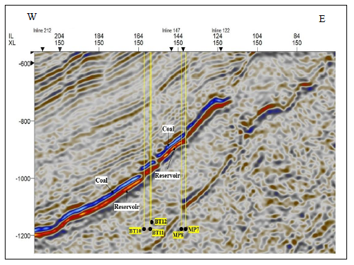
Fang basin is the first oil field of Thailand located in Fang district, Chiang Mai province, northern Thailand. The basin can be divided into three zones, northern, central, and southern zones. Ban Thi oil field is in the central zone. The petroleum distribution of the field is evaluated from isoparametric maps. The reservoir layers are in Mae Sod formation, which is sandstone interbedded with shale and coal beds. Hydrocarbon appears in the sandstone under the coal bed. The well logging data (gamma-ray, resistivity, neutron porosity, and bulk density) are from five boreholes. The isoparametric maps are constructed from the pay thickness, shale volume (Vsh), total porosity (t), effective porosity (eff), hydrocarbon saturation (Sh), and water saturation (Sw) calculated from the well logging data. The boundary of the hydrocarbon zone is interpreted from 3D seismic data. From the isoparametric maps, wells located in the northwestern and southwestern zones have higher hydrocarbon saturation than those in the central zone. These findings correspond with the interpretation of hydrocarbon boundary from the seismic data. The total reservoir area is 1,144.422 acres (4.63 square kilometers), and the hydrocarbon-bearing reservoirs are distributed in the northwestern and southwestern zone. Therefore, the litho-saturation cross-plots and the isoparametric maps can be used to assess the hydrocarbon boundary, which is essential for well planning during the exploration and production phases.

